Cold temperatures in the 20s to low 30s marked the start of the week in the Dallas-Fort Worth region.
The area is predicted to have plenty of sunlight throughout the day, with a few passing clouds, despite the chilly start. The chilly air that moved into North Texas on Sunday will keep the high temperatures below seasonal norms even though the sun will appear.
Consequently, Monday’s temperatures will only reach the 40s and low 50s, with cool northeastern winds keeping the temperature crisp.
Monday’s beautiful weather was caused by a high-pressure system, which is predicted to dominate the North Texas weather pattern through the middle of the week.
During this time, this system will maintain stable conditions and largely clear skies. But over the course of the following few days, the wind direction will start to change as the high-pressure system slowly moves eastward.
Winds from the east or southeast are predicted on Tuesday and Wednesday. Later in the week, there will probably be more cloud cover due to the additional precipitation brought in by this shift in wind direction.
Thursday is predicted to bring more obvious cloudiness and a minor probability of light showers as the week goes on. The increasing moisture and cloud formation may result in a few isolated showers over portions of North Texas, while precipitation is not assured.
Late Thursday and early Friday will see another change in the surface winds, this time from the west or southwest. Temperatures will climb sharply as a result of this shift in wind direction, which will bring warmer air.
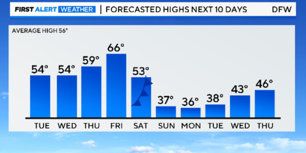
The Dallas-Fort Worth region is expected to experience a warming trend by Friday, with high temperatures expected to rise into the mid- to upper-sixties. There will be a big change coming up, so residents are urged to enjoy the nice weather on Friday.
Generous Donation: Pechanga Tribe Contributes $500K to Help Los Angeles Fire Survivors
On Saturday, an Arctic front is predicted to move into North Texas. The area will get significantly colder as a result of this front’s precipitous temperature decrease.
Although forecasts suggest that this bout of Arctic air will probably be drier, the prediction is still subject to change as the week goes on. The probability of any kind of winter precipitation between Saturday and Sunday is currently not very high.
However, as the Arctic front draws closer, locals should remain alert and be ready for any changes to the prediction.
LA Fires: Saltwater Helps Control Flames, But Brings Long-Term Environmental Risks
The chilly air from the Arctic front is predicted to persist as the weekend turns into the first part of the next week. Winter coats and warm clothes should be kept on hand because the cold is expected to last until the first part of next week.
To make sure the community is ready for any changes, the changing weather patterns will be continuously observed and updates will be given as necessary.


