A third drenching storm is predicted for the end of the week, but Northern California is enjoying a small reprieve Wednesday from a multiday atmospheric river event that delivered high winds, flooding, and a lot of rain to places north and around San Francisco.
As towns recover from the disastrous Eaton and Palisades fires, the rain is expected to taper off in Northern California on Wednesday and move to Southern California, where it may help bring the region’s wildfire season to a close.
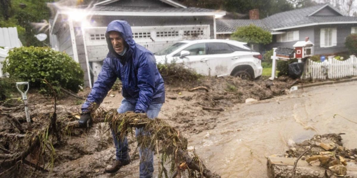
In the meantime, Northern California will be hit by another storm beginning Thursday morning. High winds and mudslides during Tuesday’s storm that led to a home collapse in Sonoma County, California, are expected to have a somewhat greater impact than that occurrence.
The house in the North Bay Area’s Forestville, California, collapsed into the Russian River.
The house was uninhabited, according to the Sonoma County Sheriff’s office. Shortly before 9 p.m. on Tuesday, the department issued an evacuation order for low-lying communities along the river.
The biggest rainfall totals since Friday have been recorded in areas north of Sacramento, with Paradise, California, reporting more than 20 inches.
The two largest reservoirs in California, Lake Shasta and Lake Oroville, have risen an astounding 15 feet since Friday alone.
A 138-year-old record that had been in place since 1887 was broken Tuesday when 2.89 inches of rain fell on downtown San Francisco.
In addition to bringing destructive winds, the multiday atmospheric river felled a large area of trees surrounding a Santa Rosa, California, elementary school. According to the Santa Rosa Fire Department, nobody was harmed.
North of San Francisco, the coast recorded the greatest winds, with one gusting to 90 mph. As a strong thunderstorm passed through, bringing down power lines and toppling trees throughout the city, a wind gust of 69 mph was recorded at San Francisco International Airport.
One individual was hospitalized after being hit by a falling tree, according to the San Francisco Fire Department.
Rainfall in Southern California could bring the fire season to a close
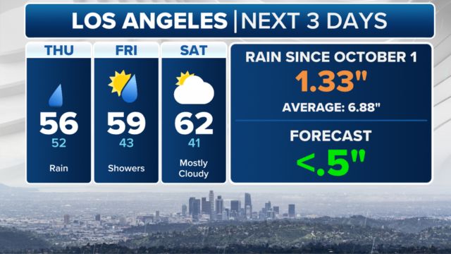
Beneficial rain will flow south toward the southern region of the state, which is now experiencing wildfires, as the current atmospheric river tapers out Wednesday in the north.
The next two rounds of rain could help finish this horrific wildfire season for Southern California and Los Angeles, as the devastating fires across the region have finally been contained.
The strongest rain was located west of the main burn scars, and the first round of moderate rain started Wednesday morning. It is anticipated that the rain will be moderate enough to lessen the likelihood of debris flows and mudslides.
Similar amounts of rain are predicted to resume on Thursday afternoon and Friday morning.
The region has been suffering from rain deficits of 5–10 inches since October, so while the rain is a very good start, it is not quite enough to stop the fire weather season.
Final Call for SNAP Recertification: Renew Before February 2025 Deadline to Keep Your Benefits
Snowfall in feet for the mountains in the West
For a significant portion of Oregon, Idaho, and Montana, winter storm warnings have been in effect through Friday AM.
In California, feet of snow are predicted for the eastern slopes of the Sierra Madre range.
From Thursday morning through Friday, extremely bad travel conditions are predicted in the Sierra Nevada.